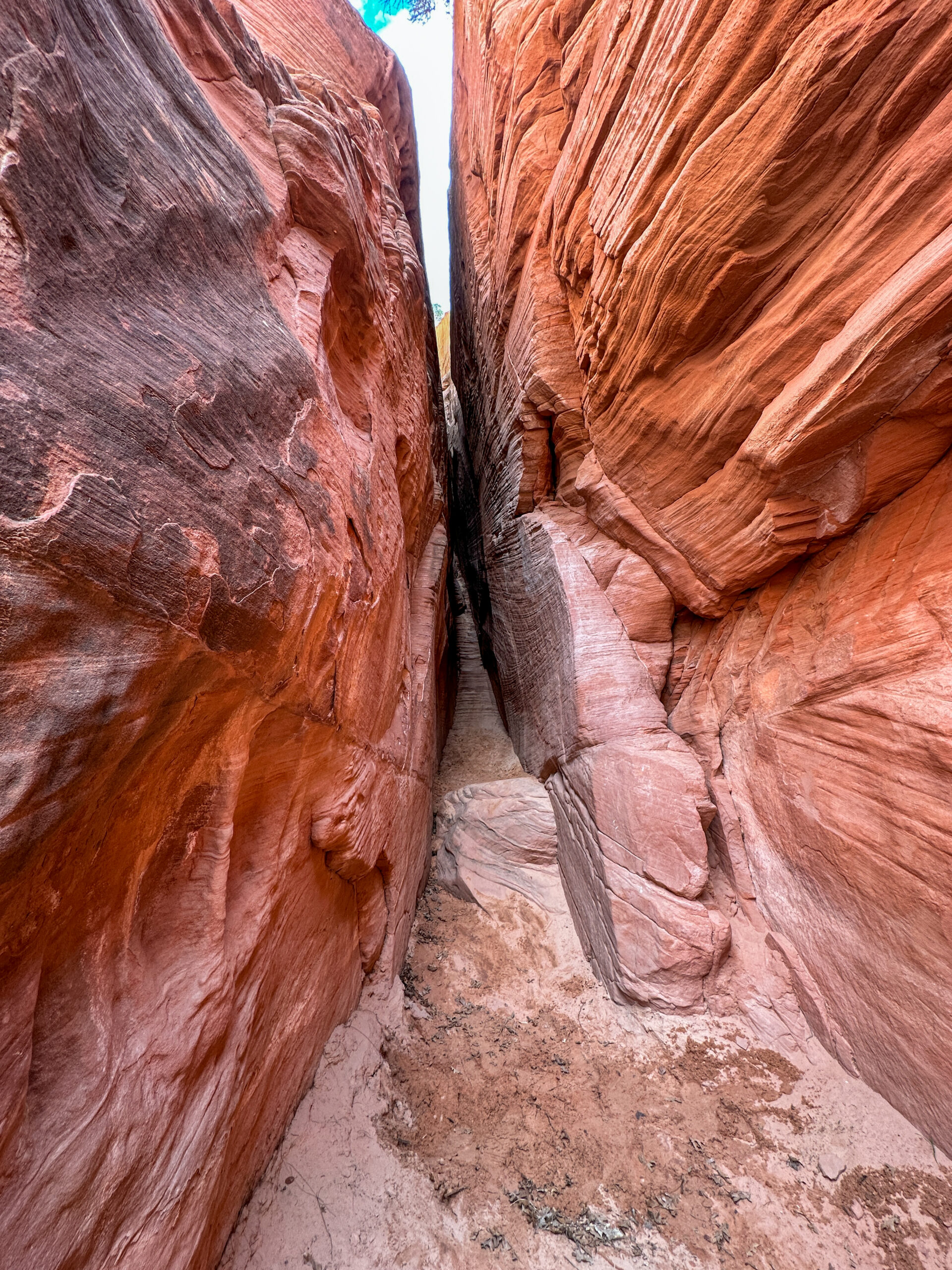
Red Hollow Slot Canyon

Red Hollow Slot Canyon: An Easily Accessible Yet Fun Slot Canyon for Families and Dogs
When planning our trip to Southern Utah for spring break, we knew we wanted the coolest hikes possible. Red Hollow turned out to be the perfect first hike to kick off the trip!
My kids love a hike that allows them to explore and has either rock or water features. This hike has zero water, but it allowed them to explore the slot canyon and the side formations. They were able to climb and run while we slogged through the deep, loose sand, and enjoyed the peace of the canyon. The hike was easy enough for my parents (74 and healthy) as well as our golden retriever. Looking back, it turned out to be one of our favorite hikes because it delivered so much enjoyment with very little effort!
Before You Go to Red Hollow Slot Canyon
What to Pack for Exploring Red Hollow Slot Canyon?
This is a relatively short out and back hike. Shoes that can handle the loose sand and slickrock are necessary. Since there is little noticeable elevation gain, this is an easy adventure. Dogs should be on a leash. Watch for cacti along the beginning of the trail that can easily dampen the fun of any hike. Tweezers and a fine tooth comb in your backpack can help with any cactus spines that cause issues.
This hike is fully exposed meaning there is NO shade. Sunscreen is a good idea year round. The hike works during any season, but plan to do this hike early in the AM or in the evening when the temps are high. Layers are a good idea during the shoulder seasons since the desert can be chilly early and late in the day. Finally, pack water for this hike even though it is short and easy. Trouble always arrives when least prepared!
Getting to Red Hollow Slot
- From Zion, follow UT-9 past the east entrance of Zion NP for 13 miles. Turn left on HWY 89 heading north until reaching Orderville.
- From Kanab, follow HWY 89 heading north to Orderville.
- Those coming from Zion/Kanab will proceed through Orderville, over the Virgin River, and turn right into a neighborhood which will wind you to the city water facility where you will find parking. Google maps was able to get us there. The map below depicts the neighborhood portion of the drive.
- For those coming from the north, you will take I-15 to exit 95 and turn left onto UT-20. Heading east on UT-20 you will turn right onto HWY 89. Head south on 89 towards Orderville, but turn left right before the bridge that goes over the Virgin River. You will be turning into a neighborhood and will follow the curving roads to the city water facility. Google maps should work. The map below highlights the neighborhood portion of the drive.
Parking & Trailhead
The parking area for the Red Hollow Trailhead is in a neighborhood off Highway 89 in Orderville, Utah. The gravel lot has limited parking. There is no overflow parking for this hike. This is a short hike which is good because there are no restroom facilities at this location.
The trailhead is barely marked at the edge of the parking lot. We were not sure which direction to head until we pulled up a map we had a screenshot of from the night before. That helped us locate the trailhead and was a great reminder to BRING A MAP! There are not many trail markers on the hike, but it is easy to follow the trail.
The trail is accessible to those who can move without assistance in loosely packed sand/soil/rock and can navigate safely on slickrock. Strollers, walkers, and wheelchairs will not work on this trail. Tours on horseback frequent the trail and the corral is next to the parking area.
Red Hollow Slot Adventure Guide Printable
For your convenience, I have a single page printable with all this information available in one concise spot. Save the Red Hollow Slot Adventure Guide to your files for easy digital access or to print and take with you. Enjoy!
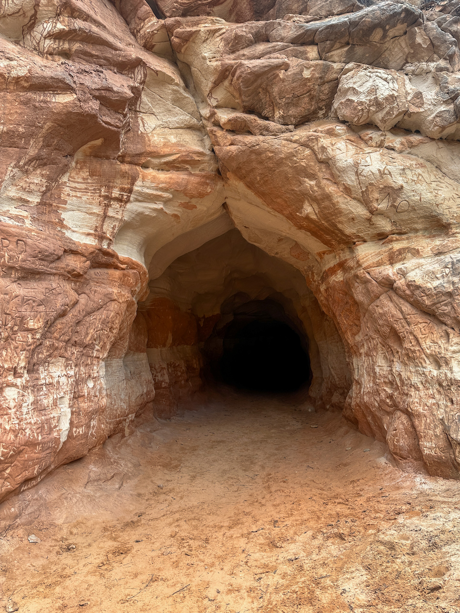
Belly of the Dragon

Who can resist a hike into the belly of a dragon? This is more a tourist attraction than an actual hike for the majority who pause along Highway 89 to check it out. If you and your crew are only interested in the "belly," this can be a 30 minute scenic detour. If you would like a longer adventure, the trail does extend beyond the tunnel for just under two miles out and back. Most people check out the tunnel and move on to their next destination. Belly of the Dragon can easily be done on the way to/from Zion for anyone staying in Kanab. When you get home, your kids will enjoy telling everyone they went into the belly of a dragon when hiking in UT!
Before You Go Into the Belly
What to Pack & Trail Tips
If you are simply stopping to see the tunnel, you will not need much more than appropriate footwear and a light source. Appropriate footwear includes: hiking boots, trail shoes, tennis shoes, Tevas, Keenes, or Chacos. Basically, any shoe that can handle loose sand and uneven rocky surfaces while protecting your feet. We always carry water bottles in the desert no matter how short the hike, so I would recommend a water bottle as well.
A headlamp or light source is helpful on this hike as the tunnel is rocky and dark. You can use the flashlight on your phone, but a headlamp leaves hands free and is easier to use. The tunnel is accessed by clambering down a 5ft concrete embankment which means older adults and young children may need assistance. Our golden retriever was able to hop down and scramble back up by himself. Once in the tunnel, watch your footing while you make your way under Highway 89. This tunnel is actually used for drainage, and you can see the ripples in the stone walls from years of water wearing down the rock. Please resist the urge to add to the graffiti and markings. It is disappointing to see so many permanent markings on this hike.
Getting There & Parking
- Belly of the Dragon is 1/2 mile outside of Carmel Junction, UT on HWY 89.
- Belly of the Dragon hike is 16 miles north of Kanab, UT on HWY 89.
- Access the parking area by turning onto Elephant Gap Rd which is a dirt road found between two guardrails off HWY 89. Drive 1/3 of a mile to the parking lot.
- The gravel parking area can accommodate many cars and, if the lot happens to be full, it would be short wait to find a space. This is a very quick "hike."
- There are no restroom or water facilities.
Adventure Guide Printable
For your convenience, I have a single page printable with all this information available in one concise spot. Save the Belly of the Dragon Adventure Guide to your files for easy digital access or print and take with you. Enjoy!
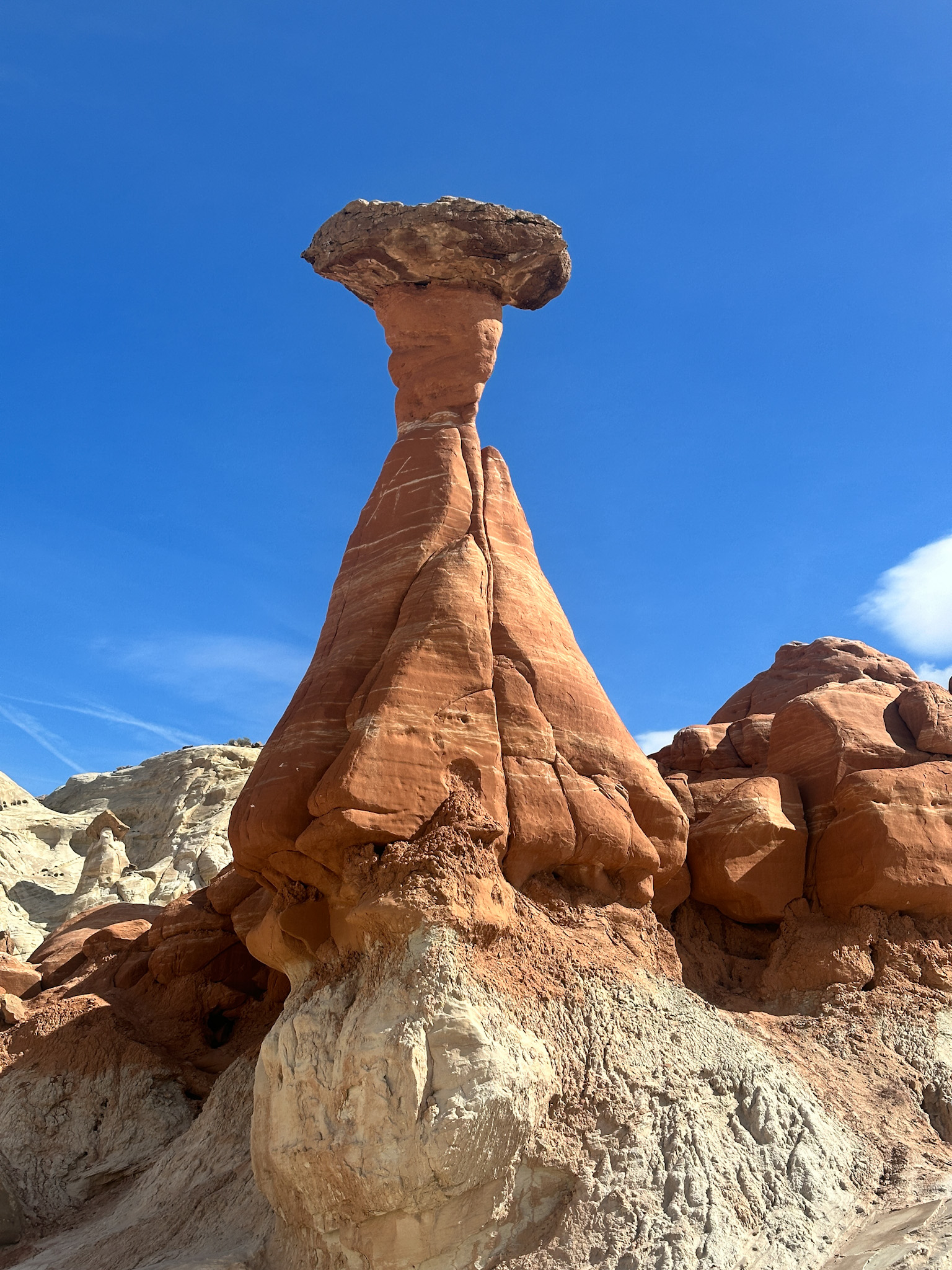
Toadstools Hike
Family-Friendly Hiking in Kanab, UT: The Toadstools Trail Guide
When your kids announce they are tired of looking at boring rocks on their their hikes, take them to see toadstools. They will feel like they are stepping into a Star Wars set with the vast expanse of white and red rock in various mushroom-like formations. These hoodoos are rock formations where a large, harder rock sits on top of a narrower, softer rock pedestal making it look like a mushroom or toadstool. These enormous formations feel more like a natural sculpture garden than the mushrooms the kids jump on playing Mario Brothers, but the kids enjoyed them almost as much. We hit this trail with two teens, two kids, grandparents, and our dog in tow. It was a hit with everyone!

Before You Go on the Toadstools Hike
What to Pack to See the Hoodoos?
This is a relatively short out and back hike. Plan for a few hours to hike to the formations and then wander around checking them out. Packing a snack to snack to eat while absorbing the silence and presence of these structures is a good idea. Just remember that everything you brought with you on the way in must go with you back to your vehicle - including tiny wrappers, gum, and bottle caps!
This hike is fully exposed meaning there is NO shade. Sunscreen is a good idea year round. The hike works during any season, but plan to do this hike early in the AM or in the evening when the temps are high. Layers are a good idea during the shoulder seasons since the desert can be chilly early and late in the day. Finally, remember to pack enough WATER. I cannot emphasize enough how important water is for desert hikes!
Getting There
- Toadstools hike is 30 miles west of Page, AZ on HWY 89 and parking will be on your right hand side.
- Toadstools hike is 45 miles east of Kanab, UT on HWY 89. Parking on your left.
- The trailhead is just past milepost 20.
Parking & Trailhead
The parking area for the Toadstools hike is clearly marked off Highway 89 in Utah. The lot is gravel and has space for plenty of cars although during tourist season it can get busy. There is no overflow parking for this hike. Portable restrooms are located in the parking lot and were clean (ish) when we visited in March (off season). There were no hand washing options. We always pack extra toilet paper, plastic bags for garbage, and ways to safely wash our hands when out on hiking adventures.
The trailhead is clearly marked at the edge of the parking lot. There are not many trail markers on the hike, but it is easy to follow the trail. Remember to avoid getting off the trail or taking shortcuts. The trail is accessible to those who can move without assistance in loosely packed sand/soil/rock and can navigate safely on slickrock. Strollers, walkers, and wheelchairs will not work well on this trail. Small children and babies will be best in a carrier.

Adventure Guide Printable
For your convenience, I have a single page printable with all this information available in one concise spot. Save the Toadstools Adventure Guide to your files for easy digital access or print and take with you. Enjoy!
Hiking Buckskin Gulch: A Multi-Generational Adventure on Wire Pass Trail
[vc_row row_height_percent="100" override_padding="yes" h_padding="2" top_padding="5" bottom_padding="5" back_image="499" back_image_auto="yes" back_position="center bottom" overlay_color="color-rgdb" overlay_alpha="20" gutter_size="3" column_width_percent="100" shift_y="0" z_index="0" enable_bottom_divider="default" bottom_divider="gradient" shape_bottom_h_use_pixel="true" shape_bottom_height_percent="100" shape_bottom_color="color-jevc" shape_bottom_opacity="30" shape_bottom_index="0" content_parallax="5" uncode_shortcode_id="174485" overlay_color_type="uncode-palette" shape_bottom_color_type="uncode-palette"][vc_column column_width_percent="100" position_vertical="middle" align_horizontal="align_center" gutter_size="2" style="dark" font_family="font-165032" overlay_alpha="50" shift_x="0" shift_y="0" shift_y_down="0" z_index="0" medium_width="0" mobile_width="0" parallax_intensity="4" parallax_centered="yes" width="1/1" uncode_shortcode_id="718693"][vc_custom_heading auto_text="yes" heading_semantic="h1" text_size="fontsize-142558" uncode_shortcode_id="129462"]Automatic Heading Text[/vc_custom_heading][vc_empty_space empty_h="0"][/vc_column][/vc_row][vc_row unlock_row="" row_height_percent="0" override_padding="yes" h_padding="2" top_padding="4" bottom_padding="4" overlay_alpha="50" gutter_size="3" column_width_percent="100" shift_y="0" z_index="0" row_height_use_pixel="" uncode_shortcode_id="104306"][vc_column column_width_use_pixel="yes" gutter_size="3" font_family="font-165032" overlay_alpha="50" shift_x="0" shift_y="0" shift_y_down="0" z_index="0" medium_width="0" mobile_width="0" zoom_width="0" zoom_height="0" column_width_pixel="800" uncode_shortcode_id="671492"][uncode_info_box items="Author|no_avatar|inline_avatar|display_prefix" text_size="h4"][vc_column_text text_lead="yes" uncode_shortcode_id="178085"]Tucked away in the Paria Canyon - Vermilion Cliffs Wilderness is an easily accessible slot canyon that will impress everyone in the family. We recently took on the magnificent Wirepass Trail to hike the iconic Buckskin Gulch in Utah, and guess what? We did it with grandparents, kiddos, and even our dog, Oliver!
Why Wire Pass and Buckskin Gulch Slot Canyons?
Buckskin Gulch is known for its towering walls and breathtaking scenery. It's one of the longest and deepest slot canyons in the world, making it a bucket-list destination for any outdoor enthusiast. Plus, it's a relatively family-friendly hike with plenty of built-in adventure. Photographers will enjoy the way light plays off the 175 million year old Navajo Sandstone along with hues of red and orange amidst the desert varnish on rocks smoothed by centuries of water flow. [/vc_column_text][/vc_column][/vc_row][vc_row unlock_row_content="yes" row_height_percent="60" override_padding="yes" h_padding="0" top_padding="0" bottom_padding="0" back_color="color-lxmt" overlay_alpha="50" equal_height="yes" gutter_size="0" column_width_percent="100" shift_y="0" z_index="0" row_height_use_pixel="" uncode_shortcode_id="184174" back_color_type="uncode-palette"][vc_column column_width_use_pixel="yes" position_vertical="middle" gutter_size="2" override_padding="yes" column_padding="3" overlay_alpha="50" shift_x="0" shift_y="0" shift_y_down="0" z_index="0" medium_width="0" mobile_width="0" zoom_width="0" zoom_height="0" width="1/2" uncode_shortcode_id="491611" column_width_pixel="450"][vc_custom_heading text_size="h1" text_uppercase="" uncode_shortcode_id="182585"]Table of Contents[/vc_custom_heading][uncode_list uncode_shortcode_id="113305"]
[/uncode_list][/vc_column][vc_column column_width_percent="100" gutter_size="3" override_padding="yes" column_padding="0" overlay_alpha="0" shift_x="0" shift_y="0" shift_y_down="0" z_index="0" medium_width="0" mobile_width="0" zoom_width="0" zoom_height="0" width="1/2" uncode_shortcode_id="356690" mobile_height="350"][vc_single_image media="145150" media_width_percent="100" uncode_shortcode_id="162802"][/vc_column][/vc_row][vc_row unlock_row="" row_height_percent="0" override_padding="yes" h_padding="2" top_padding="4" bottom_padding="4" overlay_alpha="50" gutter_size="3" column_width_percent="100" shift_y="0" z_index="0" content_parallax="0" row_height_use_pixel="" uncode_shortcode_id="192249" row_name="before-you-go"][vc_column column_width_use_pixel="yes" gutter_size="3" font_family="font-165032" overlay_alpha="50" shift_x="0" shift_y="0" shift_y_down="0" z_index="0" medium_width="0" mobile_width="0" zoom_width="0" zoom_height="0" column_width_pixel="800" uncode_shortcode_id="462399"][vc_custom_heading text_size="h1" text_uppercase="" uncode_shortcode_id="833822"]Before You Go[/vc_custom_heading][vc_column_text text_lead="yes" uncode_shortcode_id="202137"]Before hitting the trail, it's essential to secure a permit for hiking in Buckskin Gulch. Permits help manage the number of visitors and ensure the preservation of this fragile ecosystem.
You can obtain permits online at recreation.gov or at the Grand Staircase-Escalante National Monument Visitor Center in Kanab. Adults, dogs, and kids all require a permit. Day use permits can be purchased in advance or the day of; overnight permits must be secured in advance.
Remember, respecting these regulations helps keep this natural treasure pristine for future generations to enjoy! Our entire group commented that the small fee for the permit seemed warranted given the cleanliness of the restrooms, ample parking, and clean trail.
The trail is open for day use from sunrise to sunset unless you have secured an advance overnight permit. [/vc_column_text][/vc_column][/vc_row][vc_row unlock_row_content="yes" row_height_percent="100" override_padding="yes" h_padding="0" top_padding="0" bottom_padding="0" back_color="color-lxmt" overlay_alpha="50" equal_height="yes" gutter_size="0" column_width_percent="100" shift_y="0" z_index="0" content_parallax="0" row_height_use_pixel="" uncode_shortcode_id="941543" back_color_type="uncode-palette"][vc_column column_width_percent="100" gutter_size="3" override_padding="yes" column_padding="0" overlay_alpha="0" shift_x="0" shift_y="0" shift_y_down="0" z_index="0" medium_width="0" mobile_width="0" zoom_width="0" zoom_height="0" width="1/2" uncode_shortcode_id="177239" mobile_height="350"][vc_single_image media="145161" media_width_percent="100" uncode_shortcode_id="825298"][/vc_column][vc_column column_width_use_pixel="yes" position_vertical="middle" gutter_size="3" override_padding="yes" column_padding="4" font_family="font-165032" overlay_alpha="50" shift_x="0" shift_y="0" shift_y_down="0" z_index="0" medium_width="0" mobile_width="0" zoom_width="0" zoom_height="0" width="1/2" uncode_shortcode_id="127981" column_width_pixel="450"][vc_custom_heading text_font="font-165032" text_size="h1" text_height="fontheight-357766" css_animation="parallax" parallax_intensity="4" text_uppercase="" subheading="— Christopher Morley" uncode_shortcode_id="210809"]Heavy hearts, like heavy clouds in the sky, are best relieved by the letting of a little water.[/vc_custom_heading][/vc_column][/vc_row][vc_row unlock_row="" row_height_percent="0" override_padding="yes" h_padding="2" top_padding="4" bottom_padding="4" overlay_alpha="50" gutter_size="3" column_width_percent="100" shift_y="0" z_index="0" row_custom_slug_check="yes" content_parallax="0" row_height_use_pixel="" uncode_shortcode_id="114795" row_custom_slug="What-to-Pack" row_name="what-to-pack"][vc_column column_width_use_pixel="yes" gutter_size="3" font_family="font-165032" overlay_alpha="50" shift_x="0" shift_y="0" shift_y_down="0" z_index="0" medium_width="0" mobile_width="0" zoom_width="0" zoom_height="0" column_width_pixel="800" uncode_shortcode_id="936392"][vc_custom_heading text_size="h1" text_uppercase="" uncode_shortcode_id="122044"]What to Pack[/vc_custom_heading][vc_column_text text_lead="yes" uncode_shortcode_id="181200"]
- Stay Hydrated: Bring plenty of water for everyone, including your furry friend. It's essential to stay hydrated, especially in the desert heat.
- Wear Comfortable Shoes: Good hiking or tennis shoes with grip are a must, as some sections of the trail can be slippery or rocky. Tevas and Keenes worked for my kids and I.
- Pack Snacks: Keep everyone's energy levels up with healthy snacks like trail mix, fruit, and energy bars. If you have younger kids, save a few high value snacks for the last portion of the hike when the views are less enthralling and energy is low!
- Respect Nature: Remember to follow leave no trace and respect the environment. Pack out all trash and be mindful of wildlife.
[/vc_column_text][/vc_column][/vc_row][vc_row unlock_row="" row_height_percent="0" override_padding="yes" h_padding="2" top_padding="4" bottom_padding="4" overlay_alpha="50" gutter_size="3" column_width_percent="100" shift_y="0" z_index="0" content_parallax="0" row_height_use_pixel="" uncode_shortcode_id="201353" row_name="getting-there"][vc_column column_width_use_pixel="yes" gutter_size="3" font_family="font-165032" overlay_alpha="50" shift_x="0" shift_y="0" shift_y_down="0" z_index="0" medium_width="0" mobile_width="0" zoom_width="0" zoom_height="0" column_width_pixel="800" uncode_shortcode_id="936392" width="1/2"][vc_custom_heading text_size="h1" text_uppercase="" uncode_shortcode_id="882630"]Getting There:
House Rock Valley Rd & Parking[/vc_custom_heading][vc_column_text text_lead="yes" uncode_shortcode_id="189883"]Navigating the 8 mile access road to Wire Pass Trailhead is like driving through a scene from an old Western movie—dusty roads flanked by towering cliffs and desert landscapes stretching as far as the eye can see. The road, although unpaved, is generally well-maintained and accessible by most vehicles right off Highway 89. A 4x4 is NOT required for this adventure, but I always advise checking road conditions before heading out as the road can get rough. The road is impassable to all vehicles when wet due to the fact that it is heavy clay and will become slick when saturated.
We were surprised by the size of the parking lot out in the middle of nowhere. There is a main lot and an overflow lot. Parking on the road is not permitted. Once parked, sign in at the trail register. It was fun to see where all the people hitting the trail that day were from. Despite the busy parking lot and full register, we did not feel at all crowded on the trail in late March. [/vc_column_text][/vc_column][vc_column width="1/2"][/vc_column][/vc_row][vc_row unlock_row="" row_height_percent="0" override_padding="yes" h_padding="2" top_padding="4" bottom_padding="2" overlay_alpha="50" gutter_size="3" column_width_percent="100" shift_y="0" z_index="0" content_parallax="0" row_height_use_pixel="" uncode_shortcode_id="748635" row_name="trailhead"][vc_column column_width_use_pixel="yes" gutter_size="3" font_family="font-165032" overlay_alpha="50" shift_x="0" shift_y="0" shift_y_down="0" z_index="0" medium_width="0" mobile_width="0" zoom_width="0" zoom_height="0" column_width_pixel="800" uncode_shortcode_id="384313"][vc_custom_heading text_size="h1" text_uppercase="" uncode_shortcode_id="135049"]Trailhead[/vc_custom_heading][vc_column_text text_lead="yes" uncode_shortcode_id="974448"]One of the perks of starting our hike at the Wire Pass Trailhead was the availability of restroom facilities—a luxury in these remote parts of Utah! Clean and well-maintained, these facilities offer a touch of comfort before heading off into the desert. Although the line was steady for the vault toilets, it moved quickly. Bring your own method for hand cleaning and remember to pack out all garbage![/vc_column_text][vc_custom_heading text_size="h1" text_uppercase="" uncode_shortcode_id="201216"]Wire Pass Trail[/vc_custom_heading][vc_column_text text_lead="yes" uncode_shortcode_id="474011"]Starting off from the Wire Pass Trailhead, we were immediately greeted by the rugged beauty of the Utah desert. The Coyote Wash portion of the trail is completely exposed and was the least interesting part of our hike. The kids had plenty of energy when we started and found several small reptiles while the adults took in the desert vegetation - some starting to bloom in late March - and the ever-changing colors of the nearby rock formations. On the way back to the car, this stretch seemed particularly grueling in the direct sun. Fortunately, this portion has no noticeable elevation changes, is relatively short, and leads to memorable rock formations and adventures.
Once our group reached Wire Pass, we were enchanted with the change in temperature, interplay of light and dark amongst the rocks, and the swirling patterns of color on the sandstone. In late March, we wore layers and had taken off our long sleeves during the exposed portion of the hike in Coyote Wash. However, my parents (74 years old) put their jackets back on once we were out of the direct sun and the air was impacted by the coolness of the rocks we were climbing down into. The hike to the confluence is not difficult but does require some scrambling in parts. Due to flash floods and their ability to change the landscape quite dramatically, you may want to check in with a ranger before the hike for current trail conditions.
While Buckskin Gulch is a family-friendly hike, there are a few things to keep in mind:
- A Ladder: Shortly after entering Wire Pass, there is an approximately 8 foot drop to be navigated via ladder. The dog had to be carried since it was too far of a drop/jump for him to do safely. He weighs about 70 lbs, and this was the most difficult part of the experience for him. All members of our group from 9 to 74 were able to safely handle the ladder for the trip out and back.
- Narrow Passages: Some sections of the slot canyons can be quite narrow, requiring a bit of maneuvering. Make sure everyone in your group is comfortable with tight spaces. We had to climb under or over trees and boulders in several places. Obstacles can change with each flash flood the canyon experiences!
- Flash Flooding: Always check the weather forecast before heading out. Flash floods can occur in slot canyons, so it's essential to be prepared and know the signs of approaching danger. You can check with a local ranger station the day before or check this government site. Be sure to check the weather in the surrounding locations, because precipitation in upper elevations flows down to Wire Pass and Buckskin Gulch.
- Elevation Changes: The trail has very little elevation change, but take it slow and steady especially if you're hiking with grandparents or young children.
[/vc_column_text][/vc_column][/vc_row][vc_row unlock_row="" row_height_percent="0" override_padding="yes" h_padding="2" top_padding="4" bottom_padding="4" overlay_alpha="50" gutter_size="3" column_width_percent="100" shift_y="0" z_index="0" content_parallax="0" row_height_use_pixel="" uncode_shortcode_id="828267"][vc_column column_width_use_pixel="yes" gutter_size="3" font_family="font-165032" overlay_alpha="50" shift_x="0" shift_y="0" shift_y_down="0" z_index="0" medium_width="0" mobile_width="0" zoom_width="0" zoom_height="0" column_width_pixel="800" uncode_shortcode_id="384313"][vc_custom_heading text_uppercase="" uncode_shortcode_id="157804"]Buck Skin Gulch - Wire Pass Confluence[/vc_custom_heading][vc_single_image media="145154" media_width_percent="100" uncode_shortcode_id="172773"][/vc_column][/vc_row][vc_row unlock_row="" row_height_percent="0" override_padding="yes" h_padding="2" top_padding="4" bottom_padding="4" overlay_alpha="50" gutter_size="3" column_width_percent="100" shift_y="0" z_index="0" content_parallax="0" row_height_use_pixel="" uncode_shortcode_id="383765" row_name="points-of-interest"][vc_column column_width_use_pixel="yes" gutter_size="3" font_family="font-165032" overlay_alpha="50" shift_x="0" shift_y="0" shift_y_down="0" z_index="0" medium_width="0" mobile_width="0" zoom_width="0" zoom_height="0" column_width_pixel="800" uncode_shortcode_id="384313"][vc_custom_heading text_size="h1" text_uppercase="" uncode_shortcode_id="109477"]Points of Interest[/vc_custom_heading][vc_column_text text_lead="yes" uncode_shortcode_id="174767"]
- Wire Pass: The first slot canyon acts as a connector to the famous Buckskin Gulch, and is a breathtaking slot canyon in its own right.
- Wirepass Arch: This enormous arch is visible on the right when exiting Wire Pass Slot. It's a natural wonder that serves as a perfect photo op for the family!
- Confluence: About 3 miles in, you'll reach the confluence where Wirepass and Buckskin Gulch meet. It's a beautiful spot to take a break, have a picnic, and soak in the beauty of two canyons merging into one.
- Petroglyphs: In the area of the confluence, just past the arch, look for petroglyphs on the rock. Remember to take photos, but do not touch the artwork. Oil from our skin can damage these precious insights into indigenous life.
- Buckskin Gulch: Turn RIGHT when entering Buckskin Gulch, and you will be surrounded by towering walls of Navajo sandstone. The narrow passages and swirling patterns on the walls are simply awe-inspiring. Turning LEFT leads to less impressive views.
[/vc_column_text][/vc_column][/vc_row][vc_row row_height_percent="0" overlay_alpha="50" gutter_size="3" column_width_percent="100" shift_y="0" z_index="0" content_parallax="0" row_height_use_pixel="" uncode_shortcode_id="197851"][vc_column column_width_percent="100" gutter_size="2" overlay_alpha="50" shift_x="0" shift_y="0" shift_y_down="0" z_index="0" medium_width="0" mobile_width="0" zoom_width="0" zoom_height="0" uncode_shortcode_id="122335"][vc_gallery el_id="gallery-187970" isotope_mode="packery" medias="531,530,529,528,527,526,502,499" gutter_size="2" screen_lg="1000" screen_md="600" screen_sm="480" single_width="3" images_size="four-three" single_overlay_opacity="50" single_padding="2" uncode_shortcode_id="371676"][/vc_column][/vc_row][vc_row unlock_row="" row_height_percent="0" override_padding="yes" h_padding="2" top_padding="4" bottom_padding="4" overlay_alpha="50" gutter_size="3" column_width_percent="100" shift_y="0" z_index="0" content_parallax="0" row_height_use_pixel="" uncode_shortcode_id="101041" row_name="wrap-up"][vc_column column_width_use_pixel="yes" gutter_size="3" font_family="font-165032" overlay_alpha="50" shift_x="0" shift_y="0" shift_y_down="0" z_index="0" medium_width="0" mobile_width="0" zoom_width="0" zoom_height="0" column_width_pixel="800" uncode_shortcode_id="384313"][vc_custom_heading text_size="h1" text_uppercase="" uncode_shortcode_id="513881"]Wrap Up[/vc_custom_heading][vc_column_text text_lead="yes" uncode_shortcode_id="122033"]Hiking Buckskin Gulch with three generations of our family was an unforgettable experience filled with laughter, awe-inspiring sights, and precious moments shared together. It's a testament to the fact that adventures are best when shared with loved ones, no matter their age or furry status!
If you're looking for a family-friendly hiking destination that offers both beauty and adventure, Buckskin Gulch via Wirepass Trail should definitely be on your list. Happy trails, fellow adventurers! [/vc_column_text][/vc_column][/vc_row]